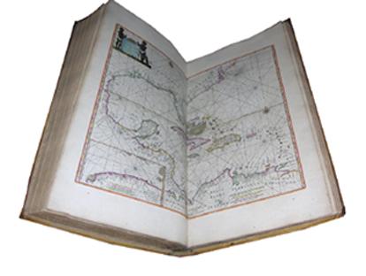
Atlas of the Day: De Zee-Atlas ofte Water-Weereld, waer in vertoont werden alle de Zee-Kusten van het bekende des Aers-Bodems. GOOS, Pieter (1616?-1675).
FIRST COMPLETE EDITION OF ONE OF THE MOST BEAUTIFUL EARLY DUTCH SEA ATLASES, and a FINE TALL COPY.
Folio, Dimensions: 24 x 13 4/8 inches
Folio, Dimensions: 24 x 13 4/8 inches
- Based on Hendrick Doncker's "Zee-Atlas" of 1659, particularly for its charts, and reprinted several times without much revision: 20 editions of this work were published between 1666 and 1683, a testament to its enduring popularity. The atlas was available with either 40 or 41 charts, the extra chart being the most desirable: "Paskaerte van de Zuydt en Noordt Revier in Nieu Nederlandt", present here
- This is the first printed Dutch sea-chart to focus on the Dutch possessions in New York, showing the Dutch colony of New Amsterdam with the settlements on Manhattan, Staten Island and Long Island, south to Delaware Bay, and including the lower course of the Delaware River.
- The atlas also includes the celebrated chart "Paskaert van Nova Grenada, en t'Eylandt California", which is one of the two earliest Dutch printed charts to focus on the "island" of California.
- Goos was an accomplished engraver, and his great achievement was to create an aesthetically striking atlas to be consulted in a library environment.
Offered at $390,000. We intend to have the lowest prices on ABE, Alibris, Biblio, AE, and Artnet while maintaining the highest levels of quality in the business for every offering. To inquire for a full offering, please contact our curators at info@aradernyc.com or call our 72nd Street NYC gallery at (212) 628-3668.

Comments
Post a Comment