A Classic American Book, Containing Some of the Earliest and Most Beautiful Lithographed Views of the Rockies and Pacific Northwest

WARRE, Henry James (1819-1898).
Sketches in North America and the Oregon Territory.
[London:] Dickinson & Co., [1848.]
$175,000
 Broadsheet (21 4/8 x 14 4/8 inches). Publisher's slip
advertising binding options tipped-in to first text leaf (without the
dedication leaf found in some copies). Lithographed map and 20 FINE tinted
lithographed views after Warre on 16 sheets (wear with small losses in margins
of text leaves and some guards, some of these with small, old repairs, plates
with light wear and light spotting near blank edges, one plate with short
marginal tears). Original cloth-backed printed paper wrappers (gutta percha
perished leaving all leaves loose, front wrapper chipped and with repaired tear
near spine, finger-sized loss to rear wrapper, some soiling).
Broadsheet (21 4/8 x 14 4/8 inches). Publisher's slip
advertising binding options tipped-in to first text leaf (without the
dedication leaf found in some copies). Lithographed map and 20 FINE tinted
lithographed views after Warre on 16 sheets (wear with small losses in margins
of text leaves and some guards, some of these with small, old repairs, plates
with light wear and light spotting near blank edges, one plate with short
marginal tears). Original cloth-backed printed paper wrappers (gutta percha
perished leaving all leaves loose, front wrapper chipped and with repaired tear
near spine, finger-sized loss to rear wrapper, some soiling).
Provenance: with the ownership inscription of ?'S.R.G.' on
the front wrapper.
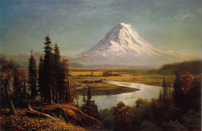
 FIRST EDITION, IN THE ORIGINAL WRAPPERS, OF THIS MAGNIFICENT
SERIES OF PACIFIC NORTHWEST VIEWS, including dramatic images of Puget Sound,
Mount Hood, and multiple views of the Columbia River and of the Rocky
Mountains, most peopled with small figures of Native Americans in the
foreground. A few scenes, such as the view of Fort Vancouver, depicted on the
same plate with the scene of an "Indian tomb" (a canoe about to be
launched on its final voyage), delicately evoke the poignancy of colonization.
These are some of the earliest and most beautiful lithographed views of the
Rockies and Pacific Northwest.
FIRST EDITION, IN THE ORIGINAL WRAPPERS, OF THIS MAGNIFICENT
SERIES OF PACIFIC NORTHWEST VIEWS, including dramatic images of Puget Sound,
Mount Hood, and multiple views of the Columbia River and of the Rocky
Mountains, most peopled with small figures of Native Americans in the
foreground. A few scenes, such as the view of Fort Vancouver, depicted on the
same plate with the scene of an "Indian tomb" (a canoe about to be
launched on its final voyage), delicately evoke the poignancy of colonization.
These are some of the earliest and most beautiful lithographed views of the
Rockies and Pacific Northwest.
The Oregon country had been “jointly occupied by American
and English settlers since 1818; by the 1840s both nations looked to annex the
territory to gain an outlet to the Pacific. Spurred by the interests of the
Hudson's Bay Company, the British viewed the Columbia River as the appropriate
boundary between Canada and northwest America. Expansionists in the United
States looked much further north and coined the latitudinal slogan "54º40'
or Fight!" In 1845, in anticipation that war might break out in Oregon,
Captain Henry James Warre was sent out of Montreal in secret to survey the
region. As a British officer, Warre had been trained to sketch the landscape;
during the arduous fourteen-month journey by canoe, boat, and horseback, he
made more than eighty drawings. By 1846 the crisis was settled by the Oregon
Treaty, which fixed the boundary at the 49th parallel. Warre then converted his
sketches and notes into a magnificent color plate book, the most important one
published on the subject of the Pacific Northwest” (Virginia Historical Society
online). Abbey, Travel 656; Graff 4543; Howes W-114 ('the only western
color-plates comparable in beauty to those by Bodmer'); Sabin 101455; Smith
10727; Wagner-Camp-Becker 157.
Comments
Post a Comment