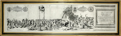
Map(s) of the Day: "A New Map of Mexico and Adjacent Provinces Compiled from Original Documents" Arrowsmith, Aaron (1750-1823).

Four-sheet engraving with early outline color
Sheet sizes: each approx. 26” x 33 1/8”
This is a first edition example of Aaron Arrowsmith's landmark "A New Map of Mexico and Adjacent Provinces…" It is a particularly rare and important foundation map of Texas and the southwest.
The coverage of this map takes in all of the present day southwestern United States from the Upper and Lower Mississippi River to California south of the 42nd parallel. The present example depicts the boundary of the Texas Louisiana border along the Mermento River and follows the official Spanish position as reported by Humboldt. This is the first large-scale map to depict the important discoveries of Pike and Humboldt in the southwest. It became highly influential to other cartographers of the era. The second state bears an altered border moved further west and north running along the Sabine and Red Rivers, as accepted by both the United States and Spain in the Adams-Onis Treaty of 1819. It includes insets of the Valley of Mexico, Veracruz and Acapulco.
"Perhaps the most respected mapmaker of the early nineteenth century, Aaron Arrowsmith produced maps which were the result of a careful synthesis of all of the information he could obtain. His map of Mexico which first appeared in 1810 was bitterly criticized by Humboldt as a blatant plagiarism of his own map. While there is no doubt that Arrowsmith did use Humboldt's data to best advantage, his map was no mere copy. For his improved rendering of the Brazos River, if for no other reason, Arrowsmith's depiction of the Texas area merits inclusion as a landmark in the cartography of the region" (Crossroads of Empire - Amon Carter Museum exhibit, June 1981).
"In interior detail…the Arrowsmith maps are quite distinct, with [that of] Mexico being far superior. Most noticeably, Arrowsmith added the Brazos River, which he had omitted entirely on the 1803 map, and he correctly named the Trinity River, which he had previously called the 'Rio Arrokisos'"
(Wheat, Transmississippi West, pp. 27-28).
(Wheat, Transmississippi West, pp. 27-28).
Literature: Crossroads of Empire -- Amon Carter Museum exhibit, June 1981; Martin; Martin 25; Phillips, America, p. 408; Streeter, Bibliography of Texas, 1406, Taliaferro 202; Wheat, Transmississippi West 295; pp. 27-28
Offered at $90,000
Arader Galleries intends to have the lowest prices on ABE, Alibris, Biblio, AE, and Artnet while maintaining the highest levels of quality in the business for every offering. To inquire or view the complete offering, please contact our curators at info@aradernyc.com or call our 72nd Street NYC gallery at (212) 628-3668.

Comments
Post a Comment