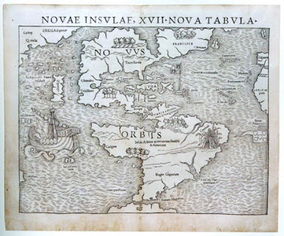
New Article: Metro Pulse Knoxville- May 5, 2011: "Charted Territory: Navigating the McClung Museum's 'Mapping the World.'"
CAPTION- "DOWN TO EARTH: The McClung Museum’s show of antique maps and navigation instruments is visually absorbing and intellectually stimulating"
"Like an old friend you rarely get around to calling but are terribly glad you did once you have, the University of Tennessee’s Frank H. McClung Museum is a gem; its rotating shows are never a waste of time. Speaking of which, I’m often amazed at the number of hours one can spend in a relatively small exhibit. Mapping the New World, at the McClung through May 22, is indeed that kind of exhibit. Although 29 maps dating from 1493 to 1847 (and navigational instruments, including a mariner’s astrolabe and rosewood backstaff, on loan from the Smithsonian Institution’s National Museum of American History) have been on display since January, there’s still a chance to see them before they’re returned to the Arader Galleries and elsewhere within a few weeks.
Shows like Mapping the New World seem entirely off the First Friday radar, despite the McClung’s proximity to UT’s Ewing Gallery. And they’re perhaps considered too academic or dull—you can’t go drinking at the end of the night with exhibitors, now dead for centuries. However, it’s fairly easy to spend the better part of an afternoon enjoying what’s currently on view from a strictly visual perspective, no matter how intellectually irresponsible that makes you. Better yet, you might learn a few things as you meander through space drenched in cabernet color with low but perfectly tuned lighting. There’s even a Windsor-esque chair and settee reminiscent of the Master and Commander era of sailing ships.
Situated at both the gallery’s entrance and exit are two flat-screen monitors presenting programs pertinent to mapping technology today, and, as relevant as talking heads describing Google Maps or MapQuest might be, they feel intrusive. University students’ grasp of ever-changing technology is now more important than ever, but Penn State Public Broadcasting’s material addressing “the geospatial revolution” is simply less captivating than maps with areas labeled “Terra Incognita” and “Enemy Mountains.” Even the exhibit’s obligatory charts, here illustrating esoteric topics like “Azimuthal Projection” and “graticules” (showing lines of latitude and longitude) are well-executed and of interest to a range of visitors.
Adjacent to the charts mentioned above, in the section of the McClung show before viewers are released from lesson time into space made magical by maps and gleaming brass objects, there’s a placard quoting David Greenhood, author of the 1951 text titled Down to Earth: Mapping For Everybody: “The world is constantly changing: war-changes and weather-changes, peace-changes and coastal-changes, for every change we need a map.”
Yet change is not all we see in maps. However frivolous they might appear, there are ornate borders, often referencing Greek gods and astrology. We see hand-colored cherubic faces—or those of rotund old men—blowing wind from various directions across graphic planes, or maps created in 16th-century Antwerp by a Flemish humanist (Abraham Ortelius) hellbent on producing “the Theatrum,” our first modern atlas. Six glass-capped pedestals and two more wall-mounted display cases feature, among other objects, a “reflecting circle” produced in the 1790s by Étienne Lenoir. An odd instrument that predates the sextant, it measures the distance between the moon and a nearby star—the so-called lunar distance method—using a telescope combined with both direct and reflected sightings.
Furthermore, in Mapping the New World we see Aaron Arrowsmith’s “Map of the United States of America,” a copperplate engraving reproduced in London in 1802, derived from geographical information obtained by Hudson Bay Company explorers and divided into four separate frames. Drawn from reports and drawings withheld for years prior, it was the most reliable map of its time. In fact, it was the map carried by Lewis and Clark on their expedition westward, a reminder of the terrifying notion that lives were often lived or lost based solely on the reliability of maps. Playing God, in a sense, the mapmakers’ slightest mistakes could alter the course of history.
There’s plenty in the McClung show for regional history buffs, as well. One of 10 maps from UT’s Special Collections is “A Draught of the Cherokee Country” by Henry Timberlake, issued with his 1762 memoir. Timberlake’s engraving reads, “On the West Side of the Twenty four Mountains Commonly Called over the Hills,” and it’s quite rough compared with other maps presented—the rendering of a river flanked by towns including Tuskeegee and Chote (Chota) is not very detailed. Those settlements, along with approximately 60 other 18th-century Cherokee communities in the Southeast, remind us of our area’s past, both glorious and shameful.
Last but not least are nine modern items on loan from Garmin, a manufacturer of various communication instruments. Among those instruments representing different GPS applications is a sporting dog’s collar that allows its master to follow a trail as well as know the animal’s momentary location. Compared to objects impeccably crafted from fine materials, the Garmin devices resemble a batch of remote controls from your den, but they represent tremendous leaps in our ability to navigate the planet we inhabit."


Comments
Post a Comment