Skip to main content
Search
Search This Blog
Graham Arader
@aradergalleriesnyc | aradernyc.com | 1016 Madison Avenue
Posts
Showing posts with the label
Rare Map Offerings
Show all
Graham Arader
Graham Arader
October 22, 2018
California as an Island
Graham Arader
Graham Arader
February 04, 2014
Map of the Day: "West Indische Paskaert" Johannes Loots
Graham Arader
Graham Arader
February 04, 2014
Map of the Day: "A Map of the British and French Dominions in North America." John Mitchell.
Graham Arader
Graham Arader
February 04, 2014
Maps of the Day: Set of Continents by William Janszoon Blaeu (1571-1638)
Graham Arader
Graham Arader
February 04, 2014
Rare Map of the Day: "Europa from Novus Atlas" Henricus Hondius, 1631
Graham Arader
Graham Arader
October 14, 2011
Rare Map of the Day: "Mappe-monde Geo-Hydrographique ou Description Generale de Globe Terrestre et Aquatique en Deux Plans-Hemispheres, . . ." Louis Brion de la Tour, after Alexis-Hubert Jaillot, 1782
Graham Arader
Graham Arader
October 13, 2011
Rare World Map of the Day: “Nova Totius Terrarum Orbis Geographica ac Hydrographica...” Claes Janszoon Visscher, 1639 (1652)
Graham Arader
Graham Arader
October 06, 2011
Rare Map of the Day: "Insulae Americanae” from “Theatrum Orbis Terrarum" Willem Janszoon Blaeu, 1645
Graham Arader
Graham Arader
September 28, 2011
Rare Map of the Day: "Londinum from Civitates orbis terrarum" Georg Braun and Frans Hogenberg. 1572-1618
Graham Arader
Graham Arader
September 21, 2011
Rare Map of the Day: "Map of the Counties of New York, Queens, Kings & Richmond" David H Burr, 1829
Graham Arader
Graham Arader
September 15, 2011
Rare Map of the Day: "Generaele Karte van West Indien" Arent Roggeveen (d. 1679) and Jacob Robijn (d. c. 1710)
Graham Arader
Graham Arader
September 09, 2011
Rare Map of the Day: "Map of the United States, Exhibiting the Post-Roads, the Situations, Connexions & Distances of the Post-Offices..." Abraham Bradley, Jr.
Graham Arader
Graham Arader
September 07, 2011
Offering of the Day: "Carte du theatre de la guerre entre les Anglais et les Americains...." Louis Brion de la Tour, 1777
Graham Arader
Graham Arader
August 31, 2011
Map of the Day: "An Accurate map of North and South Carolina With Their Indian Frontiers" Henry Mouzon, 1775
Graham Arader
Graham Arader
August 19, 2011
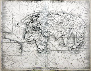
Rare Map Offering of the Day: " Orbis Typus Universalis Ivxta Hydrographorum Traditionem." Martin Waldseemuller (1570-1614)
Graham Arader
Graham Arader
August 18, 2011
Rare Map/City Plan of the Day: "Plan of the City and Suburbs of New Orleans" Jacques Tanesse, 1825
Graham Arader
Graham Arader
August 16, 2011
Rare Map Offering of the Day: " Isola d. Sardegna." Joan Oliva (1570-1614)
Graham Arader
Graham Arader
August 10, 2011
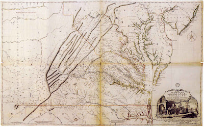
Map of the Day: "A Map of the Inhabited Part of Virginia containing the whole province of Maryland with part of Pensilvania, New Jersey and North Carolina." Peter Jefferson and Joshua Fry
Older Posts
Home