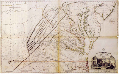
Map of the Day: "A Map of the Inhabited Part of Virginia containing the whole province of Maryland with part of Pensilvania, New Jersey and North Carolina." Peter Jefferson and Joshua Fry
ONE OF ONLY FOUR EXISTING FIRST EDITION, FIRST STATE EXAMPLES OF THE MOST IMPORTANT 18TH CENTURY MAP OF VIRGINIA
Even More Notable for Being the Personal Copy of Jacques Nicolas Bellin, Chief Mapmaker to the French Government During a Period that Included the French and Indian War and the American Revolution
Peter Jefferson and Joshua Fry
"A Map of the Inhabited Part of Virginia containing the whole province of Maryland with part of Pensilvania, New Jersey and North Carolina"
Engraved map on four sheets with original hand color: paper size 30 1/8” x 48 3/8”
Stamp of the French hydrographic office (Dépôt de la Marine), manuscript inscription on verso: “Pour Mr. Bellin Ingenieur de la Marine”
London: Thomas Jefferys, 1751
The map, compiled by Peter Jefferson and Joshua Fry in the first years of the 1750s, is all but unrivaled in its significance for the history of the mapping of Virginia, and of North America as a whole. It went through several editions and states (alterations to the printing plates), and each version is of extreme rarity, but none more so than this map: a recently unearthed example -- only the fourth known in existence -- of the very first state of the first edition. The three other copies are in the collection of the New York Public Library, in the Alderman Library at the University of Virginia, and in the collection of the of Duke of Northumberland at Alnwick. This exceedingly rare map is the only one to have become available in recent memory, and is further distinguished for being the personal copy of the most celebrated French cartographer, Jacques Nicolas Bellin, head of the government hydrographic office. It was this example of Fry and Jefferson’s seminal map that Bellin consulted during the crucial military campaigns that took place over the course of two wars waged on American soil, the French and Indian War, which pitted the French against the British, and the Revolution, in which the French again found themselves opposite the English, this time in alliance with the Americans. This is the map that Bellin would have used as a point of departure for his own maps of the region, and that he would consulted in order to advise the French commanders during critical military maneuvers that held momentous historical import.
The Fry-Jefferson map of the broad area known as Virginia is the fundamental cartographic document of the region from the 18th century. The first map to focus on Virginia was Captain John Smith's of 1612, but after that early and primitive attempt to delineate the area, no exhaustive study was made for over a century. This basic lack was first confronted by the team of Peter Jefferson -- the father of Thomas Jefferson -- and Joshua Fry. The two men were commissioned by the Virginia legislature after a 1751 mandate, issued by the English Lords of Trade, requiring each colony to produce an adequate survey of the region. Fry's experience as master of mathematics at William and Mary, and Jefferson's as a surveyor, was enough to recommend them as commissioners for the compilation of the Virginia map.
The result of the ambitious collaboration between the two men was the most accurate, comprehensive, and complete project in the history of Virginia mapping. The Fry-Jefferson map was the first to delineate the interior regions of Virginia beyond the Tidewater, and included all the major plantations along Virginia's rivers by family name. It was the first printed map to depict the valleys of the Appalachian and Allegheny mountain ranges of the western interior, and to show the complete Virginia river system. The striking cartouche at the lower right is one of the earliest surviving pictorial representations of the Virginia tobacco trade, and a testament to the fact that Fry and Jefferson ensured the same quality in the map's artwork as in its cartography. Historically, this is the most valuable and influential early map of Virginia. This particular example represents an unprecedented opportunity to own one of America's most important cartographic documents of the colonial era.
Offered at $750,000.
Arader Galleries intends to have the lowest prices on ABE, Alibris, Biblio, AE, and Artnet while maintaining the highest levels of quality in the business for every offering. To inquire or view the complete offering, please contact our curators at info@aradernyc.com or call our 72nd Street NYC gallery at (212) 628-3668.


Comments
Post a Comment