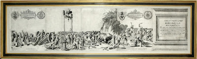
Map of the Day: "An Accurate map of North and South Carolina With Their Indian Frontiers" Henry Mouzon, 1775
The Most Important 18th-Century Map of the Carolinas, Used by Washington in the Revolutionary War


Henry Mouzon
"An accurate Map of North and South Carolina With Their Indian Frontiers"
Published in Thomas Jefferys's "American Atlas"
Copperplate engraving: two sheets, each app. 21” x 55”
London: Sayer & Bennett, 1775
Henry Mouzon's landmark map of the Carolinas was the primary source for the American, English and French armies during the Revolutionary War. George Washington's copy of the map, folded and backed on cloth so it could be safely transported in his saddlebag, is today in the collection of the American Geographical Society. The example owned by Lieutenant General J.B.D. de Vimeur Rochambeau, who with his French troops marched alongside Washington to Yorktown, is in the Library of Congress, and the copy owned by the British general Henry Clinton is in the William L. Clements Library in Ann Arbor. That the foremost figures of the War for Independence relied on this map does not begin to indicate its importance and influence. For over fifty years, Mouzon's map was the source for information about the geography and topography of the Carolinas, and was copied frequently by other mapmakers for its amazing detail and accuracy.
Mouzon based his map on years of personal surveying experience, as well as over a decade spent critically assessing and incorporating previous information. For North Carolina, Mouzon inserted for the first time Tryon County, Pelham County (later called Sampson), and the topography west of the Catawba River is more detailed and accurate than on any previous map. Mouzon also advanced beyond earlier maps in his inclusion of rivers, streams, roads, and physical features like "White Oak or Tryon Mountains" and "Kings Mountain." For South Carolina, Mouzon added rivers and Indian settlements west of the Cherokee Indian boundary lines, and his depiction of the eastern precincts was more sophisticated than anything that had come before. Besides details of natural features, Mouzon's map depicts forts, parishes, bridges, roads, Indian paths, and boundaries, and includes insets of Charleston and Port Royal harbors. This is truly a landmark map. Its excellence above preceding depictions of the vast Carolinas was recognized by all countries involved in the Revolutionary War, and it remained unrivaled well into the 19th century.
Offered at $48,000
Arader Galleries intends to have the lowest prices on ABE, Alibris, Biblio, AE, and Artnet while maintaining the highest levels of quality in the business for every offering. To inquire or view the complete offering, please contact our curators at info@aradernyc.com or call our 72nd Street NYC gallery at (212) 628-3668.
==============================================
Please do not hesitate to direct all comments, questions, and inquiries to grahamarader@gmail.com

Comments
Post a Comment