Rare Map/City Plan of the Day: "Plan of the City and Suburbs of New Orleans" Jacques Tanesse, 1825
"ONE OF THE FINEST EXAMPLES OF 19th CENTURY URBAN CARTOGRAPHY"
-John Reps

Jacques Tanesse’s Plan of New Orleans
Drawn by Jacques Tanesse
Engraving, Engraved by William Rollinson
Plan of the City and Suburbs of New Orleans
Paper size: 20 3/8” x 32 1/4”
Frame size: 31 1/2” x 43 3/4”
Published New York: Charles Del Vecchio & New Orleans: Pierre Maspero, 1825
References: M. Fielding, American Engravers upon Copper and Steel... (Philadelphia, 1917) 1294; I.N. Phelps Stokes & D.C. Haskell, American Historical Prints Early Views of American Cities, Etc. (New York, 1932) F-6; J.W. Reps, Cities of the American West (Princeton, 1979) 21, fig. 1.17; G.G. Deak, Picturing America, 1497-1899 (Princeton, 1988) 292; J.J. Poesch (ed.), Printmaking in New Orleans (Jackson, 2006) 78-79, fig. 9
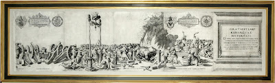
This detailed engraving far surpasses any other printed view or map of New Orleans. Made by the surveyor Jacques Tanesse, the plan is an aerial projection from a height distant enough to give a good idea of the city’s crescent shape. John Reps, Cornell University professor emeritus and cartographic scholar, calls Taness’s work “one of the finest examples of 19th-century American urban cartography.” By August 1817, the map was available in New Orleans when Tanesse presented two copies to the city, one for the mayor’s office, the other for the council chamber.
The city’s various states of progress in the its expansion are superbly charted in the plan’s neat grid layout, which is accentuated by large open places given over to public plazas and buildings. Tanesse also includes the breastworks that proved to be very decisive in America’s defeat of the British during the famous Battle of New Orleans in January of 1815. This interesting detail is shown perpendicular to the Mississippi River at the lower right-hand corner of the city plan. Twelve symmetrically placed border insets show the city’s most important buildings, and all are drawn in elevation, with an occasional attempt at perspective. Although simply executed, they represent the French, Spanish, and American periods of New Orleans history. In the title cartouche, an exotic American Indian family of unknown tribe poses near a lion skin. Here is where the second printed view of the city is depicted - the cathedral flanked by the Cabildo and the Presbytère. Today, as a note, it stands with a second story that has been added by the U.S. government to facilitate its use as a courthouse.
Jacques Tanesse’s plan was issued in two states: the first in 1817 and this the second edition in 1825. This example, from the 1825 issue, celebrates the visit of General Lafayette to New Orleans, where he makes noteable changes that took place to the city in the intervening eight years. Tanesse engraves the sixty-foot triumphal arch which was built in wood and canvas and erected at the Place d’Armes for the occasion of the General’s arrival. This he sets at the bottom of the map on land across the river, which misleadingly suggests that it stood there. The arch was designed by city architect Joseph Pilié and painted to resemble marble by Jean Baptiste Fogliardi, the scene painter for the Théâtre d'Orléans. Another significant alteration is Tanesse’s addition of a tower to the cathedral. The original rectangular format was adapted with the clever device of a lunette breaking the top of the border to accommodate the height of the new spire.
Offered at $35,000.
Arader Galleries intends to have the lowest prices on ABE, Alibris, Biblio, AE, and Artnet while maintaining the highest levels of quality in the business for every offering. To inquire or view the complete offering, please contact our curators at info@aradernyc.com or call our 72nd Street NYC gallery at (212) 628-3668.
==============================================
Please do not hesitate to direct all comments, questions, and inquiries to grahamarader@gmail.com
==============================================
Please do not hesitate to direct all comments, questions, and inquiries to grahamarader@gmail.com

Comments
Post a Comment