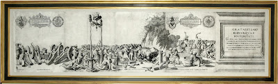
Rare Map Offering of the Day: " Orbis Typus Universalis Ivxta Hydrographorum Traditionem." Martin Waldseemuller (1570-1614)

Martin Waldseemuller (1470 - 1521)
Orbis Typus Universalis Ivxta Hydrographorum Traditionem
29 1.2 x 35 inches
Woodcut
References: Rodney W. Shirley, The Mapping of the World (London, 1983), n. 35.
Substantiating this retraction is another map in the same volume. On the regional map of the Caribbean and Atlantic Ocean ("Tabula Terre Nove"), South America is labeled "Terra Incognita" (unknown land) and bears an inscription indicating that these lands were discovered by Columbus, with no indication of Amerigo Vespucci's role in the exploration of the northern coast of South America. Waldseemuller extended the map southwards and westwards in order to show discoveries in Africa and the rest of the southern hemisphere by Columbus and Pedro Alvares Cabral. The map focuses on the Caribbean islands of Hispaniola and Isabella (Cuba) and much of the northern coast of South America and of Brazil. A vague indication of Labrador is also given. This map is also available here through Arader Galleries New York City.
Arader Galleries intends to have the lowest prices on ABE, Alibris, Biblio, AE, and Artnet while maintaining the highest levels of quality in the business for every offering. To inquire or view the complete offering, please contact our curators at info@aradernyc.com or call our 72nd Street NYC gallery at (212) 628-3668.
==============================================
Please do not hesitate to direct all comments, questions, and inquiries to grahamarader@gmail.com
==============================================
Please do not hesitate to direct all comments, questions, and inquiries to grahamarader@gmail.com

Comments
Post a Comment