Lieutenant Amiel Weeks Whipple’s Proof Copy of “Report of Explorations for a Railway Route, near the Thirty-Fifth Parallel of North Latitude, from the Mississippi River to the Pacific Ocean”

WHIPPLE, Lieutenant
Amiel Weeks (1818 – 1863) – IVES Lieutenant J.C.
THE AUTHOR’S PROOF
COPY OF “Report of Explorations for a Railway Route, near the Thirty-Fifth
Parallel of North Latitude, from the Mississippi River to the pacific Ocean”.
[Washington, D.C.]: War Department, 1853-4 [but 1856].
$75,000
4to., (11 2/8 9
inches). General title-page, 3 sectional title-pages (old vertical fold marks
to text leaves). FOUR FINE FOLDING MAPS NOT INCLUDED IN THE PUBLISHED VOLUME:
“Map of Routes for a Pacific Railroad Compiled to accompany the Report of the
Hon. Jefferson Davis... 1855”, “Profiles of Rail Roads Constructed across the
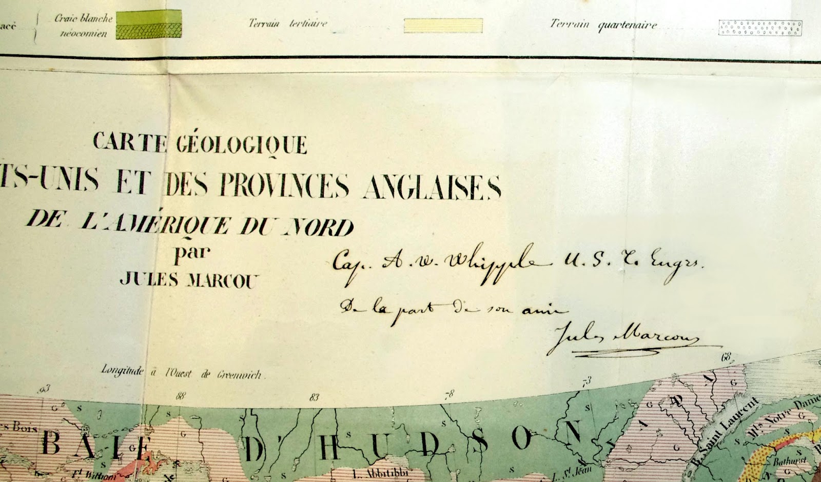
Alleghany Mountains”, Jules Marcou’s chromolithographed “Carte Geologique des
Etas-Unis et des Provinces Anglaises de l’Amerique du Nord” THE FIRST
GEOLOGICAL MAP OF AMERICA here affectionately inscribed
“Cap. A.W. Whipple U.S. C. Engs. De la part de son ami Jules Marcou,
and “Geologische Karte der Vereinicten Staaten und Britischen Provinzen
von Nord-Amerika”. Illustrated throughout with an ORIGINAL GRAPHITE AND
WATERCOLOUR DRAWING BY MOLLHAUSEN, EXCEPTIONALLY FINE PROOF
CHROMOLITHOGRAPHS BEFORE LETTERS signed by the lithographer J. Sinclair,
uncoloured proof lithographs after letters, some of plates in their final
state, and all wood-engravings in the text. Contemporary half green morocco,
blue cloth, gilt (just a bit rubbed).
Provenance: The author
of the Report Amiel Weeks Whipple, by descent to the most recent owner.

THE AUTHOR’S OWN PROOF
COPY OF HIS REPORT OF HIS EXPLORATION OF THE 35TH PARALLEL, published as volume
III of the monumental 12 volume “Reports of Explorations and Surveys to
Ascertain the Most Practical and Economic Route for a Railroad from
the Mississippi River to the Pacific Ocean. 1853-1854.” Washington:
[Printed by Beverley Tucker], 1855 -1860.
Including proof text
leaves for Part I: “Itinerary” illustrated with AN ORIGINAL APPARENTLY
UNPUBLISHED GRAPHITE AND WATERCOLOUR DRAWING BY MOLLHAUSEN OF BILL
WILLIAMS MOUNTAIN ARIZONA, signed by Mollhausen lower right and tipped in
to heavier stock. Mollhausen was a Prussian artist, who visited the United
States three times in the 1850s, which provided him with the material and
experiences he used to produce illustrations, diaries, and fiction for nearly
fifty years. “His works made him enormously popular with Germans of all ages
and classes, and he has become known as "the German Cooper". After
arriving in the United States in 1849 and working in the Midwest, in
1851 Möllhausen traveled through the Plains toFort Laramie with Prince
Paul of Württemberg. He returned to Germany in 1852 with a shipment
of wild animals for the Berlin zoo and met Alexander von Humboldt. He
soon became a favorite of the old explorer and, bearing a recommendation from
Humboldt, returned to the United States, where he joined Lt. Amiel Weeks
Whipple's Pacific Railroad survey of the Thirty-fifth parallel as
"topographer or draughtsman." The party traveled from Fort
Smith, Arkansas, to Pueblo de los Angeles in 1853-54.
Möllhausen made several illustrations
in the Texas Panhandle that appear in Whipple's report" (Kathleen Doherty
for Texas State Historical Association).
Mollhausen recorded
his delight on seeing Bill Williams’ Mountain in his own diary, published
in English as the “Diary of a Journey from the Mississippi to the Coasts of the
Pacific with a United States Government Expedition... with an Introduction by
Alexander von Humboldt ... translated by Mrs. Percy Sinnett” London: Longman
(and others), 1858: “after we had gone a short distance through the forest, we
passed to the south of a high mountain, which we called Mount Sitgreaves, after
the captain of that name. Some smaller hills that immediately surrounded us hid
for a time the San Francisco Mountains lying to the north-east; but,
by way of compensation, we had towards the south-west a clear prospect of the Bill
Williams’ group, covered with pines and cedars and obviously distinct
volcanoes” (page 111 English edition).
In addition the
“Itinerary” includes 6 PROOF chromolithographs, before letters, signed by the
lithographer J. Sinclair lower right, many published in this section of the
original account but also containing two that were published with the account
of the “India Tribes” later in the book; and 7 further tinted or uncoloured lithographs
after letters.
This proof copy of
Whipple’s report also includes Parts II “Topographical Features”, and III
“Indian Tribes”, the latter with two PROOF lithographs before letters and
signed by Sinclair, a further proof in which the caption has been corrected,
and 2 colour plates of artifacts. However it does not include the report on the
Geological findings published in the third volume, nor the Zoological report
later found in the tenth volume of the eventual 12 volume edition.
Instead copies of
Jules Marcou’s original reports in French and German are included at the end.
Accompanied by his updated versions of his “Carte Geologique des Etas-Unis et
des Provinces Anglaises de l’Amerique du Nord” from “Annales des Mines” second
series, volume VII, page 329 (Marcou 49) here inscribed “Cap. A.W. Whipple U.S. C.
Engs. De la part de son ami Jules Marcou”.
“The first
geological map comprising the whole country from the Atlantic to the Pacific
Oceans, the author being the first geologist to cross the continent with a
Government expedition - the Pacific Railroad exploration" (Marcou 48). Both the French and the German editions of this map are
attractive and colourful, focusing on the United States, but also including a good portion of Canada and the Baja. Each identifies
by color twelve different geological structures, extends the geological
coverage to the Pacific, and on the French edition includes a fine geological
profile across the top.
In this proof copy
Marcou’s reports appear as their entire offprint issues: “Rapport Sur un
Memoire de M. Jules Marcou, relatif a la classification des chaines de
montagnes d’une partie de l’Amerique du Nord” from “Comptes rendus des seances
de l’Academie des Sciences” Institut Imperial de France. Academie des Sciences.
Volume 40, 2nd April 1855. And “Uber die Geologie der Vereinigten Staaten
und der Englischen Provinzen von Nord-Amerika”. [Salins (Jura), July
1855]. Accompanied by the fine folding chromolithographed map
“Geologische Karte der Vereinicten Staaten und Britischen Provinzen von
Nord-Amerika” dated July 1855. In the final published edition they are included
as a ‘resume’. Marcou (1824 – 1898) published his extensive geology of
theUnited States in 1858.
Not included in the
final published version of volume III, but present here are “Appendices
to Report” – including Astronomical, Magnetic, Climatalogical, and Barometric
reports, as well as Horary Corrections, and Distances and Grades.
In 1849, after
completing work with the Northeastern Boundary Survey, Lt. Whipple was
assigned to the Mexican Boundary Survey team. “The peace treaty with Mexico was
recently signed, and the group was exploring great lengths of land unknown to
Americans and Europeans. Whipple’s leather-bound [diaries] provide
observations of temperature and barometric pressure, descriptions of peaceful
encounters with various tribes of American Indians, and detailed drawings of
botanical specimens and topographic sites. With the northern and southern
borders established and the discovery of gold in California, the United
States Congress saw the need for exploration of the interior lands. There
was much discussion of a super highway for travelers to safely navigate from
theMississippi River to the pacific coastline. By an act of
Congress, Secretary of War Jefferson Davis was charged to conduct surveys for
the first transcontinental railroad route to the Pacific Ocean, near the
35th parallel. Five teams were sent, the Northern, Central, and coastal
Pacific surveys were commissioned along with two Southern Pacific survey teams,
one of which was led by Lt. Whipple. The journals of this expedition are
very thorough and contain details regarding supplies, the hiring of cooks and
assistants, as well as environmental, topographical, and cultural
observations. Whipple kept records with meticulous detail, often writing
while on horseback or aboard a train, evident through his varied penmanship.
“The survey party
reached Oklahoma Territory on Friday July 15, 1853. After
a lengthy crossing of the Poteau River, the wooden cart which carried
men, supplies and surveying equipment, ran into a tree stump and was
broken. A summer storm crept up on the team and Lt. Whipple soon found
himself walking through knee deep puddles on the prairie. Sunday provided
a day of rest for the men and the animals, and by Tuesday July 19, the team had
arrived at the Choctaw Agency. Surveying the land and observing the
inhabitants gave Lt. Whipple many things to write about, and his journal
entries for the month of August are extensive and illustrate his view of the
prairie (Jennifer Silvers Oklahoma Historical Society).


Comments
Post a Comment