Moll’s Map of Africa with extraordinary original color

“Africa: With all the European settlements, and federal
remarks. Dedicated to the Earl of
Peterborow.”
from The World described; or a New and Correct Sett of
Maps...
Engraving with original hand color
Sheet size: 25” x 40 1/2”
[London, 1719]
$35,000.
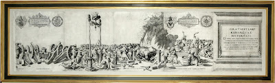
Insets: Cape Coast Castle on gold coast of Guinea, James
Fort on island of St. Helena, Fort of Good Hope, Cape of Good Hope.
This maps bears
an elaborate cartouche with wild animals and natives hunting and riding
crocodiles. Elephant and ostrich roam in the background. The east coast of South America is shown at
the left margin.
Herman Moll’s seminal atlas The World Described included
significant cartographic examples heralding the dawn of the British Empire. A
Map of the West Indies and several others in the set presented to the public a
British picture of a major colonial theater of current European conflicts, such
as the War of the Spanish Succession (Queen Anne's War) of 1702-1714, which
pitted Britain, the Holy Roman Empire, and Holland against France and Spain
over the Bourbon ascendancy to the Spanish throne. The map shows the Gulf of
Mexico and Caribbean Sea and their envrions. The atlas, of exceptional design
and resplendent with Moll's fine engraving and lettering, also contains many
messages to the user. Thus, Moll indicated with dash lines across these bodies
of waters five tracks of the fabled treasure fleets, moving from Panama,
Mexico, Cuba, and Florida to Spain. Mexico City and the harbors of "Porta
Bella," Havana, Vera Cruz, and St. Augustine, whence the riches departed,
are inset on the map. These additions helped to make Moll's map a
"buccaneer map" not only for such British privateers as Dampier and
Rogers, but also, and perhaps more importantly, for its users in the British
Isles and elsewhere in Europe.
In 1717, two years after The World Described first appeared,
Moll advertised a new edition, which like the earlier atlas contained maps in
“two sheets, all composed and done according to ye newest and exact
Observations....” His advertisement blasted his competition, for a struggle for
“territory” also existed in the mapmaking industry. “Since ye beginning of this
new Set of Maps, now completely finish’d several ignorant Pretenders have
started up, and with great Shew and Noise frequently advertised their trifling
Performances; calling them Cheap, curious, useful and correct: As to ye first
Epithet, they are really dear at any Price, in ye second Place every body may
see they are Confusedly and Poorly engraven; as for their usefulness, it tends
only to lead people into Errors and Dangers; Lastly they are so far from being
Correct, that the fundamental or Projection of their Principal maps is
Notoriously False.”
Herman Moll came to London in 1678 from Germany or Holland
and worked as an engraver for Moses Pitt. He possessed a talent for making
interesting friends and provided maps for Daniel Defoe's Robinson Crusoe and
Jonathan Swift's Gulliver's Travels. He also associated with explorer/buccaneer
William Dampier and the chemist Robert Boyle. From 1689, he operated his own
London shop. Maps of a uniquely Moll character, including his beautiful
signature lettering, began to appear during Queen Anne's reign, and his
individual style of mapmaking grew increasingly more distinct as his career
progressed. Herman Moll was one of the most significant and distinctive European
cartographers of the late seventeenth and early eighteenth centuries. He
enjoyed a lengthy and productive career that spanned almost six decades and
yielded more than two dozen geographies, atlases, and histories, as well as
myriad separate maps, charts and globes spanning the known world. He possessed
a strong and tasteful design sense that, when combined with his engraving
talents, led to the creation of unique and aesthetically pleasing maps, many of
which are considered graphic masterpieces. Moll and his maps also flourished
during the fascinating and dynamic era of the British Enlightenment and the
early, heady days of empire.
The cartographer eventually became part of a number of
impressive circles that gathered regularly at London coffeehouses and which
included, among others, the scientist Robert Hooke, the writers Daniel Defoe
(Robinson Crusoe) and Jonathan Swift (Gullivers Travels), the buccaneers
William Dampier and Woodes Rogers, and the field archeologist and antiquarian
Rev. Dr. William Stukeley. Over the years these men and others came together in
loosely knit and shifting groups and developed an intellectual and commercial
interdependence around the themes of geography, cartography, literature and
empire.

Comments
Post a Comment